
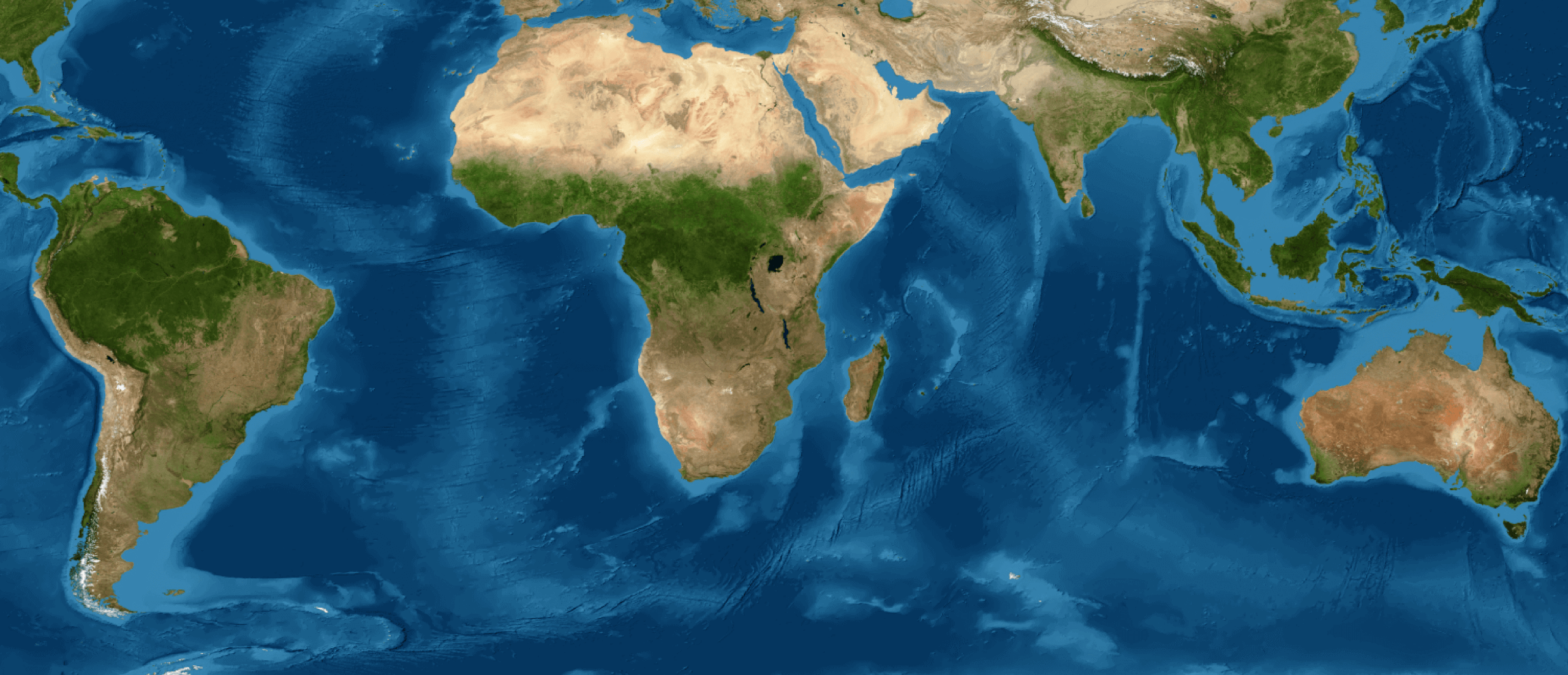
It is the result of collection 1 of annual land cover and use maps between 1998 and 2022 generated by MapBiomas Argentina
In the last 25 years, 7.6 million hectares of natural vegetation were lost in Argentina, including both trees and shrubs (woody) and grasslands, mainly concentrated in the north of the country, in the provinces of Santiago del Estero, Salta, Chaco and Formosa, which is equivalent to 3 times the province of Tucumán. These data were revealed from collection 1 of annual land cover and use maps between 1998 and 2022, generated free of charge and publicly by MapBiomas Argentina in its recent release.
The platform offers an unprecedented vision of the Argentine territory in a context of climate vulnerability linked to droughts and floods in different regions of the country. It gathers information on land cover and use in the country, surveying areas of natural woody vegetation, bodies of water, grasslands, steppes, forests, and areas of agriculture and pasture, among others. It provides essential information for research and contribution to the sustainable development of the country. It will improve the management and monitoring of natural resources, solidly supporting territorial planning and conservation strategies for nature and its biodiversity.
The initiative is a collaboration of experts in remote sensing and natural resources from research institutes and civil society organizations who, through the processing of satellite images, generated this first collection of 25 annual maps with 15 classes of land cover and use. “The MapBiomas methodology proposes cyclical work, in each collection there is learning that is incorporated by the team so that the next maps are better while adding new challenges” Ana Eljall.
Some of the data extracted from Collection 1, "MapBiomas Argentina: Building a collaborative network for mapping land cover and use (1998-2022)", reveal that:
- Natural vegetation represents 70% of the country and 28% is closed and open woody (79 Mha). The woody component includes trees and shrubs that can be found distributed in a more or less concentrated manner in the landscape.
- The loss of Closed Woodlands was concentrated in the north of the country, in the provinces of Santiago del Estero (2.1 Mha), Salta (1.5 Mha) and Chaco (870 thousand ha).
- Anthropic use classes such as agriculture, livestock and forestry plantations cover 55.5 Mha, equivalent to twice the province of Buenos Aires.
- Between 1998 and 2022, the agricultural area increased by 5.2 Mha and pastures by 1.4 Mha; while forest plantations increased by 37%.
- 97% of Patagonia is natural vegetation and unvegetated area (80.5 Mha). At the local level we can observe interesting patterns such as the disappearance of Lake Colhue Huapi and the loss of Patagonian forests.
¨Two of the main novelties that MapBiomas brings as a network in each member country is the generation of methodologically solid information available for free and the collective work of professionals from different institutions whose commitment is to generate information for the common good¨; highlights Mayra Milkovic Secretary of the MapBiomas Global Network.
Information about the regions: In the Northwest region (NOA) - Jujuy, Salta, Tucumán, Catamarca and Santiago del Estero; The most significant change was the decrease in the closed woody class in Santiago del Estero (2.1 Mha). Since 1998, about 10% of the region's natural vegetation (3.6 Mha) has been lost. Meanwhile, the surface area of the agricultural area increased by 16% (7.5 Mha).
In the Northeast (NEA) - Chaco, Formosa, Corrientes and Misiones; The province with the greatest increase in agricultural area was Formosa, highlighting the increase in pastures. lForest plantations in Misiones increased by 50% (100 thousand ha). In terms of loss, Chaco lost 15% of its natural Cerrada Woody coverage while in Corrientes the loss was 8% of its grasslands (281 thousand ha).
The CENTER region - Buenos Aires, La Pampa, Córdoba, Santa Fe and Entre Ríos; It is the region where half of its surface (39 Mha) was already used for agriculture at the beginning of the analyzed period. However, half of the country's grassland loss occurred in this region (300 thousand ha). Another important loss in the region was 17% of the surface occupied by surface water (266 thousand ha).
In CUYO - Mendoza, San Luis, San Juan and La Rioja; The most notable change was the increase in the agricultural area concentrated in the irrigated valleys, which grew by 28% (500 thousand ha) throughout the period. In La Rioja, the area of forest plantations increased by 19 thousand hectares while in San Luis the agricultural area reached 136 thousand hectares).
PATAGONIA - Neuquén, Río Negro, Chubut, Santa Cruz and Tierra del Fuego; It is a region in which a large part of its extension is still covered by natural vegetation and areas without vegetation (80.5 Mha). However, 66 thousand hectares of ice and snow surface were lost (8.2% of the region). At the local level we can observe interesting patterns such as the disappearance of Lake Colhue Huapi and the loss of Patagonian forests.
About MapBiomas Argentina: It is composed of experts from 18 research institutes and civil society. The network was created in 2015 in Brazil and, over the last eight years, has expanded through local institutions to countries in South America and Indonesia. In each territory, the methodology and processing are adapted according to the needs. Improvement is ongoing, and both the codes and technological applications are shared within the network and with users on the website. The data is publicly accessible, open, and free, providing an independent platform that contributes to the knowledge, conservation, monitoring, and planning of the territory (argentina.mapbiomas.org).
CONTACT: Mariana Lombardi: mariana.lombardi@vidasilvestre.org.ar